Features
Financial Reports & Markets
J.D. Irving implements enterprise GIS to enable more efficient workflows
December 1, 2010 By Pulp & Paper Canada
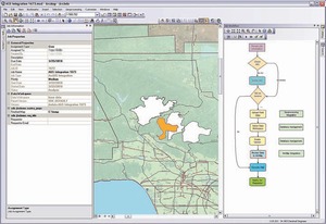 ArcGIS Workflow Manager allows you to create
 J.D. Irving has completed an enterprise geographic information system (GIS) deployment that has centralized geographic information throughout the organization and extended its GIS to other business ar…
J.D. Irving has completed an enterprise geographic information system (GIS) deployment that has centralized geographic information throughout the organization and extended its GIS to other business areas. The new GIS platform has also allowed JDI to centrally manage workflows for its forestry operations, resulting in more efficient processes.
“Centralizing our geographic information into one enterprise system has created significant efficiencies and allowed us to create standards for managing GIS data and workflows,” said Joe Pelham, GIS IS leader, IT division, JDI. “The system has helped to improve the quality of data and increased our capability for developing targeted applications to support the diverse needs of our various businesses.”
“JDI has a successful history of using GIS to manage forests sustainably,” said Alex Miller, president, ESRI Canada. JDI was the first forest products company in North America to use ESRI technology back in 1983, and has used GIS in its forestry operations to manage more than six million acres of land in New Brunswick, Nova Scotia and Maine. “While the use of GIS data and maps is inherent in forest management, users across their different lines of businesses can apply and benefit from advanced geographic analysis through their enterprise GIS. This allows them to gain unprecedented insight about their resources and workflows, enhance decision making, and strengthen JDI’s ability to meet its broad range of environmental and business objectives.”
The Irving project began in 2007 and involved migrating numerous GIS applications and hundreds of datasets managed across 10 regional offices into a single geodatabase. ESRI’s ArcGIS technology provided JDI with comprehensive functionality for building the enterprise GIS. It allows hundreds of users throughout the organization to view, edit, and distribute geographic information on servers, desktops, mobile devices and over the Web. The technology seamlessly integrates with other business systems, providing JDI with the capability to leverage GIS applications and data in their business processes.
The company also implemented the Job Tracking for ArcGIS Server extension (JTX) to improve workflow management for processes including harvesting timber, planting trees, managing wildlife habitat, building roads, and managing land ownership. JTX automates and tracks each job in the GIS workflow including loading field data, editing the enterprise geodatabase, and producing maps and reports.
The system passes the job from one user to the next, prompting for input and approvals until the entire workflow is completed. It improves user productivity by automating tasks and helps JDI to effectively manage a dispersed workforce by distributing work geographically. Staff and management can view every stage of the workflow by job type, number and priority, increasing accountability and enabling them to easily create and assign work to the appropriate resources. ESRI Canada, www.esricanada.com.
Print this page